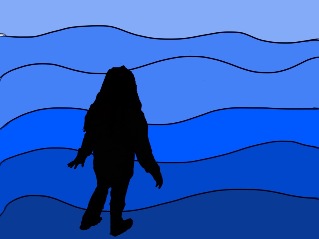
State Regions Project

You will work in groups to learn about the climate, population, native people, economy, land and waterway, natural resources, animals and plants of a USA region. Below are the steps you must complete to create a movie which will serve as a teaching tool for all the groups.

  1. Research your region with your teammates. Use the Research Guide and sites on our Regions wiki.
  2. Use the storyboard guide to create a script based upon your research.
  3. Use the iPads to collect the pictures you need for your movie from public domain sites listed on the wiki.
  4. Use Explain Everything and Skitch to put together your movie. Use screencasting techniques when it helps to explain your information.

State Glog

Today you will begin to create a glog using the information you have researched about your state. Maps and flags are in the group folder. Check Wikimedia Commons for other images. Include the following on your glog:

1. State Name          4. Three famous people
2. State Flag             5. Three tourist attractions
3. A map                  6. Three basic facts
7. Date entered statehood and number

Me On The Map

Create a slideshow that shows where you are in your neighborhood, town, state, country, continent, and planet. Each week you’ll work on one or more pages in Kid Pix. When finished, put the pages together to make a slideshow. Click the picture below for a sample of what a finished project will look like.

Map Scale

Map scale is the relationship between distances on a map and the corresponding distances on the earth’s surface expressed as a fraction or a ratio. Today you will use Google Maps at different zoom levels to measure how far 3 inches will take you from a specific point. Use the worksheet to record your location, number of feet traveled, and how long it will take you to walk the distance.

googlemaps

Crack The Code

Today you will work with a partner and visit the National Geographic website Crack The Code. It appears that thieves have stolen some very valuable maps. They fortunately dropped a scrap of paper behind with clues as to the location of the maps. However the clues are in code. Use your knowledge of latitude and longitude along with Google Earth to find the identity of eight cities. The discovery of the identity of all the cities will lead you to the maps. You may not use the Fly to Search, but must spin the globe to find the coordinates. Be sure to turn on the Google Earth grid in the View menu. Please take turns using the mouse. I will hand out a copy of the scrap paper with the clues. Use the back of the scrap paper to write down your answers. Good luck!

geo_mapskills

National Park Project

Today you will be conducting research online about your chosen National Park. Once you have gathered your information, in addition to creating a written paragraph, you will create a slide in Powerpoint which includes a picture of the state where the park is located, a couple of pictures of the park, and a reason to preserve it. Your slides will be displayed at the State Fair.

Arches

Use the following websites to gather information about the park.

WebRangers

US National Park Service

National Geographic

US Parks

World Book Online

Use the following websites to collect public domain pictures of your park.

National Park Services Images

Pics4Learning

Wikimedia Commons

Landform Flipbook

Today you will use Google Earth to find four examples of landforms. Save the images in a new folder called Landforms. Don’t forget to save a picture of the Earth for your title slide. We will create a flipbook by inserting the images and definitions for each landform into PowerPoint and printing them two slides to a page.
Need help with a definition?
Landform Glossary

Need help with a definition?
Landform Glossary

Crack The Code

Today you will work with a partner and visit the National Geographic website Crack The Code. It appears that thieves have stolen some very valuable maps. They fortunately dropped a scrap of paper behind with clues as to the location of the maps. However the clues are in code. Use your knowledge of latitude and longitude along with Google Earth to find the identity of eight cities. The discovery of the identity of all the cities will lead you to the maps. You may not use the Fly to Search, but must spin the globe to find the coordinates. Be sure to turn on the Google Earth grid in the View menu. Please take turns using the mouse. I will hand out a copy of the scrap paper with the clues. Use the back of the scrap paper to write down your answers. Good luck!

geo_mapskills

State Report Project

Today you will spend most of the period gathering information for your State Report. Use the following websites to help you. You may also use the World Book located in your applications folder.

Enchanted Learning- US States

50 States

Stately Knowledge

Explore The States

Fact Monster

During the last fifteen minutes of the class use the following websites to practice your knowledge of state capitals and locations. Use the games at home to help you study for your test!

State Game-Sheppard

Kids Geo

State Capitals

States and Capitals

National Geography Geospy

Where is That?

Find the State

Landform Slideshow

Today you will begin work on your Landform Powerpoint slideshow. You will be using Google Earth, Powerpoint, and the two Internet sites below for the project. You may choose three landforms to include in your show. Each slide must include a picture of the landform from Google Earth, a textbox identifying the location and name of the particular landform, and a sound button which includes your recording of the definition of the landform form. Create a title page using Word Art for the title and your name. I have created a sample of one slide below.

Websites for Project:
Types of Land
Landform Glossary

O’ Canada

We will begin your new unit on Canada and Mexico exploring several United Streaming videos about Canada. Use the webpages on the local hard drive to view them.

Additional resources to explore at home.

Canada For Kids
Enchanted Learning-Canada’s Geography
Time For Kids-Canada
National Geographic Kids
The World Factbook

Games

Sheppard Geography Games
Canada’s Treasure Trek
Quia Canada Game
Quia Rags to Riches

Landform Flipbook

Today you will begin work on your Landform Flip book. You will be using Google Earth, Powerpoint, and the two Internet sites below for the project. I will demonstrate how to create the book, but I also created the Voicethreads below so that you can review any procedures that you may have forgotten. You will need to create a folder in your documents folder named Landforms. This folder will store your pictures and Flipbook. It will also be helpful to use the F3 key to toggle between open windows.

Types of Landforms

Landform Glossary

Collect all of your pictures before moving on to the PowerPoint Presentation.

Landform Flipbook

Crack The Code

Today you will work with a partner and visit the National Geographic website Crack The Code. It appears that thieves have stolen some very valuable maps. They fortunately dropped a scrap of paper behind with clues as to the location of the maps. However the clues are in code. Use your knowledge of latitude and longitude along with Google Earth to find the identity of eight cities. The discovery of the identity of all the cities will lead you to the maps. You may not use the Fly to Search, but must spin the globe to find the coordinates. Be sure to turn on the Google Earth grid in the View menu. Please take turns using the mouse. I will hand out a copy of the scrap paper with the clues. Use the back of the scrap paper to write down your answers. Good luck!